Mountain flood disaster monitoring and early warning system1. Overview The mountain flood disaster warning system is an important non-engineering measure formountain flood disaster prevention. Mainly around the three aspects of monitoring, early warning and response, the water and rain monitoring system integrating information collection, transmission and analysis is integrated with the early warning and response system. According to the degree of crisis of the early warning information and the possible damage range of the mountain torrent, select appropriate Early warning procedures and methods to realize the timely and accurate uploading of warning information, implement scientific command, decision-making, dispatch, and rescue and disaster relief, so that disaster areas can take preventive measures in time according to the flood disaster prevention plan to minimize casualties and property loss. 2. The overall design of the system The mountain flood disaster warning system designed by the company is mainly based on three-dimensional geographic information technology to realize rainwater condition monitoring and rainwater condition warning. Rainwater monitoring includes subsystems such as water and rain monitoring station network, information transmission and real-time datacollection; rainwater warning includes basic information inquiry, national rustic service, rainwater analysis service, forecast water situation, early warning release, emergency response and system management, etc. The subsystem also includes the group monitoring group anti- organization and propaganda training system to give full play to the role of the mountain flood disaster warning system.
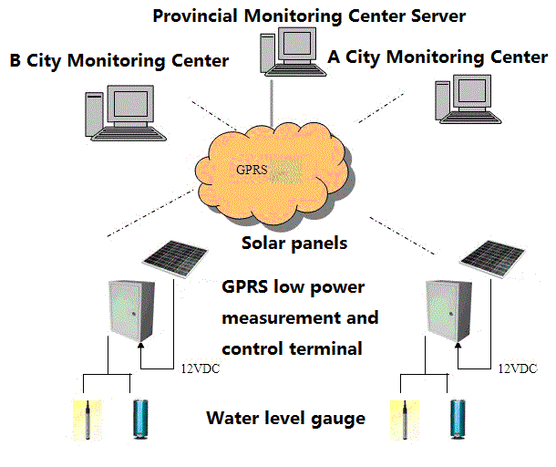
3. Water rain monitoring The rainwater monitoring of the system consists of artificial rainfall monitoring station, integrated rainfall monitoring station, automatic rainfall level monitoring station and township/townsub-central station; the system adopts a combination of automatic monitoring and manual monitoring to flexibly arrange monitoring stations. The main monitoring equipments are simple rain gauge, tipping bucket rain gauge, water gauge and float type water level gauge. The system can use the communication method in the following figure: 4. County-level monitoring and early warning platform The monitoring and early warning platform is the core of data information processing and service of mountain flood disaster monitoring and early warning system. It is mainly composed of computer network, database and application system. The main functions include real-time data collection system, basic information query subsystem, meteorological land service subsystem, and rainwater conditions service subsystem, early warning release service subsystem, etc. (1) Real-time data collection system The real-time data collection is mainly completed by the data collection and exchange middle ware. Through the data collection and exchange middle ware, the monitoring data of each rainfall station and water level station is realized in real time to the mountain flood disaster warning system. (2) The basic information query subsystem Based on the 3D geographic system to realize the query and retrieval of basic information, the information query can be combined with the mountainous terrain to make the query results more intuitive and real, and provide a visual,efficient and fast decision -making platform for the leadership decision-making process. It mainly includes the basic information of the administrative area, the information of the relevant flood prevention organization, the information of the graded flood prevention plan, the basic situation of the monitoring station, the information of the work situation, the information of the small watershed, and the disaster information. (3) Meteorological Land Service Subsystem Meteorological land information mainly includes weather cloud map, radar map, district (county) weather forecast,national weather forecast, mountain topographic map, landslide and debris flowand other information. (4) Rainwater service subsystem The rainwater service subsystem mainly includes several parts such as rain, river water, and lake water. The rain service can realize real-time rain query, historical rain query, rain analysis, rainfall processline drawing, rainfall accumulation calculation, etc. The river water service mainly includes river real-time water conditions, river history water situation query, river water level process map drawing, water level. The flow relationship curve is drawn; the lake water situation mainly includes the reservoir water situation query, the reservoir water level change process diagram, the reservoir storage flow process line, the real-time water regimeand the historical water regime process comparison, and the storage capacity curve. (5) Water condition forecasting service subsystem The system reserves an interface for flood forecasting results, and use svisualization technology to present the evolution process of forecast floods tousers, and provides services such as chart query and rendering of results. (6) Early warning release service subsystem When the rainfall or water level provided by the water forecast service subsystem reaches the warning level set by the system, the system will automatically enter the early warning function. The subsystem first issues an internal warning to the flood control personnel, and early warning to the public through manual analysis. (7) Emergency response service subsystem. After the early warning release service subsystem issues a public warning, the emergency response service subsystem automatically starts. This subsystem will provide decision makers with a detailed and complete mountain torrent disaster response workflow. In the event of a disaster, the system will provide a detailed map of the location of the disaster and various evacuation routes and provide a corresponding list query service. In response to the issue of life and property safety brought to the people by flash floods, the system also provides various rescue measures, self-rescue measures and other programs, and provides real-time feedback services for the implementation effects of these programs.
Article classification:
Geological Disaster Solution
|